

Where do you go to bike? We are fortunate to have a pretty safe path around our block and easy access to Everhart Park but these routes, while nice for the little ones, are limiting for everyone else.
A couple of times a year we’ll head out to East Goshen Park or the Chester Valley Trail, where we can ride in peace. It makes for a nice afternoon but it’s not exactly convenient to load all the bikes into the back of the car. So I’ve been on a quest to find a family-ride closer to home.
In my search, I was pointed to this bike map on the West Chester Borough website.
Safe Bike Trails Through West Chester:
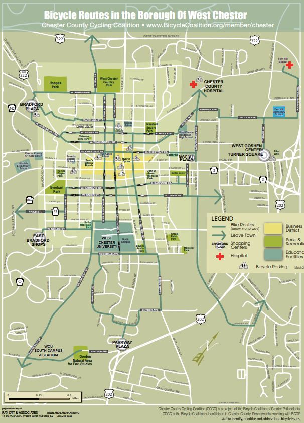
It was developed by the now retired Borough Leaders for Emissions Reductions (BLUER) in collaboration with Chester County Cycling Coalition, a project of the Bicycle Coalition of Greater Philadelphia, and it attempts to layout a safe route through town.

To further promote safe conditions for all, West Chester is adding more sharrow markings (a bike symbol with an arrow indicating both cars and and bikes are welcome here) to Borough streets. Currently only Church Street is marked, but the Public Works Department is looking to add markings to Darlington and Walnut Streets as well.
Has anyone tried it? What do you think? Where do you go for rides?
Plus, here’s where I’d ride to, if I didn’t have the kids (and I was in shape enough to handle the hills).


Leave a Reply